Fond de carte
- Titre
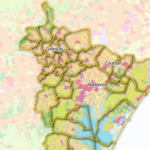
- Landuse in Narbonne, South of France
- Description
- This map shows the landuse in South of France
Data from OpenData du Grand Narbonne, en liccense ouverte (LO)
Project from

- Structure
- 3Liz
- Site internet
- https://lizmap.com
- Projection
- EPSG:2154
- Emprise
- 700665.08580000000074506, 6225961.72759999986737967, 721239.89839999994728714, 6245895.51599999982863665
- Service WMS
- WMS URL
- WMTS URL
- WFS URL
Choisir un traitement à effectuer