Fond de carte
- Titre
- Paris by night - Adding javascript, user interface customization
- Description
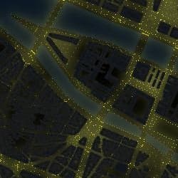
- This project shows the elements of public lighting in the center of Paris.
It shows the rendering possibilities of QGIS with free data. You can change the scale by double clicking on the map or using the navigation tools (on the right)
A click on the map displays the corresponding data under the click (streetlights)
Data: OpenData of the city of Paris && OpenStreetMap - Structure
- 3Liz
- Personne
- 3Liz
- Site internet
- http://3liz.com
- Projection
- EPSG:2154
- Emprise
- 650274.09081319929100573, 6860137.21290676575154066, 654065.9612267006887123, 6862910.45974645391106606
- Service WMS
- WMS URL
- WMTS URL
- WFS URL